
17 min read
An alternate airport is an airport where you can land if landing at your intended airport becomes inadvisable (Pilot/Controller Glossary). An instrument flight rules (IFR) flight plan must name one unless the flight meets the exception in 14 CFR 91.169.
Planning one takes two decisions: whether your flight plan needs an alternate at all, and whether the airport you choose qualifies as one.
Alternates at a glance (14 CFR 91.169, for airplanes; AIM for GPS)
- When you need one: always, unless ATC (air traffic control) authorizes otherwise, or the destination has an instrument approach and the forecast from 1 hour before to 1 hour after your ETA (estimated time of arrival) shows a ceiling of at least 2,000 feet above the airport and visibility of at least 3 statute miles (the 1-2-3 rule).
- What weather the alternate needs, at your ETA there:
- the alternate minimums published for the approach you plan to fly, or
- if none are published, 600-2 for a precision approach such as an ILS (instrument landing system), or 800-2 for a nonprecision approach, including RNAV (area navigation) approaches based on GPS (Global Positioning System), or
- if it has no instrument approach, weather that allows a descent from the MEA (minimum en route altitude), approach and landing under basic VFR (visual flight rules).
- On the chart: a triangle A means the approach has nonstandard alternate minimums or restrictions, listed at the front of the TPP (Terminal Procedures Publication). "A NA" (not authorized) means you can't use that approach for an alternate.
- GPS: without WAAS (Wide Area Augmentation System), and with FDE (fault detection and exclusion) and a RAIM (receiver autonomous integrity monitoring) prediction, plan a GPS approach at the destination or the alternate, not both. With WAAS, plan a GPS approach at the alternate on the LNAV (lateral navigation) or circling line (AIM, Aeronautical Information Manual, 1-1-17 and 1-1-18).
- Forecast groups: TEMPO (temporary) and PROB30 (30% probability) groups in a TAF (terminal aerodrome forecast) are part of the forecast. Check them against both tests.
Do you need an alternate? The 1-2-3 rule
Every IFR flight plan must list an alternate airport, unless ATC authorizes otherwise or the flight meets one exception (14 CFR 91.169(a)). Both of its conditions must hold (91.169(b)):
- The first airport of intended landing has a published instrument approach (a standard procedure in 14 CFR Part 97, or a special procedure issued to the operator).
- Weather reports, forecasts or a combination of them show that, for at least 1 hour before and for 1 hour after your ETA, the ceiling will be at least 2,000 feet above the airport elevation and the visibility at least 3 statute miles.
The Instrument Procedures Handbook (IPH) calls this the "1, 2, 3 Rule": 1 hour either side of the ETA, a 2,000-foot ceiling, 3 miles (IPH, chapter 1).
If either condition fails, you need an alternate. A destination with no instrument approach always needs one. These figures are for airplanes. Helicopters have their own in 91.169(b)(2)(ii) and (c)(1)(ii).
What counts as a ceiling
A ceiling is the lowest layer of clouds or obscuring phenomena reported as broken, overcast or obscuration, and not as thin or partial (14 CFR 1.1). In a TAF that means:
- BKN (broken) and OVC (overcast) are ceilings.
- VV, the vertical visibility into a surface-based obscuration, is an indefinite ceiling. VV008, BKN008 and OVC008 all indicate an 800-foot ceiling (National Weather Service, NWS, Instruction 10-813, B2.7.1 and B2.7.2).
- FEW (few) and SCT (scattered) aren't ceilings. A forecast of SCT008 OVC025 has a ceiling of 2,500 feet.
TAF cloud heights are forecast above ground level (NWS Instruction 10-813, B2.7.1), so you can compare them directly with the 2,000 feet above the airport elevation.
The fuel follows the same rule
When you need an alternate, you also need the fuel to fly to the destination, then to the alternate, then 45 minutes at normal cruising speed. If you meet the 1-2-3 exception, you still need fuel to the destination and then the 45 minutes (14 CFR 91.167).
Reading the TAF against the window
A TAF divides its valid period into groups. Read every group whose time overlaps your window, not only the one in effect at your ETA (NWS Instruction 10-813):
- FM (from): a rapid change, in under an hour, to a new set of prevailing conditions. Each FM group replaces the conditions before it.
- TEMPO (temporarily): fluctuations expected to last an hour or less each time and, in total, less than half of the period the group covers, which is at most 4 hours.
- PROB30: a 30% chance of a thunderstorm or precipitation event, with the visibility and clouds that come with it. A PROB30 group covers at most 6 hours. Since October 2024 it may also appear in the first 9 hours of a TAF.
TEMPO and PROB30 count
Apply the conditions in a TEMPO or PROB30 group as you would the prevailing ones, both for the 1-2-3 test at the destination and for the alternate minimums at the alternate.
Part 121 airlines covered by a Federal Aviation Administration (FAA) exemption, No. 3585, may dispatch domestic flights when conditional language in one time increment of a forecast is below their minimums and the other increments are at or above them (FAA Chief Counsel, letter to Frisch, 2011). No such exemption exists for Part 91.
If the destination has no TAF, the 1-2-3 test still needs weather reports or forecasts that show the conditions (91.169(b)(2)).
High-altitude destinations: when 1-2-3 isn't enough
The 1-2-3 rule doesn't check the destination's own approach minimums. At a few mountain airports every approach has an MDA (minimum descent altitude) more than 2,000 feet above the airport, or a visibility minimum above 3 miles. The AIM names three: Bishop and South Lake Tahoe in California, and Aspen in Colorado (AIM 5-1-10).
At those airports a forecast can relieve you of an alternate while the weather is below what any approach allows. Some other mountain airports have MDAs 1,700 to 1,900 feet above the airport. A small change from the forecast can put the weather below their minimums. The AIM cautions pilots flying to these airports to consider an alternate even when the forecast doesn't require one (AIM 5-1-10). Example 5 works through Aspen.
Does the airport qualify? Alternate minimums
To list an airport as your alternate, reports or forecasts must show that at your ETA at that airport, the ceiling and visibility will be at or above its alternate minimums (91.169(c)). The time is your arrival at the alternate, not at the destination.
| The alternate has (91.169(c)) | Weather it needs at your ETA there |
|---|---|
| An approach with published alternate minimums | Those minimums |
| A precision approach with no published alternate minimums | 600-foot ceiling, 2 miles (600-2) |
| A nonprecision approach with no published alternate minimums | 800-foot ceiling, 2 miles (800-2) |
| No instrument approach | Enough for a descent from the MEA, approach and landing under basic VFR (the weather minimums of 14 CFR 91.155) |
Precision and nonprecision for alternate planning
For alternate planning, precision approaches are the ILS, PAR (precision approach radar) and GLS (ground-based augmentation system landing system). Nonprecision approaches include NDB (nondirectional beacon), VOR (very high frequency omnidirectional range), LOC (localizer), TACAN (tactical air navigation), LDA (localizer-type directional aid), ASR (airport surveillance radar), RNAV (GPS) and RNAV (RNP), where RNP is required navigation performance (TPP, IFR Alternate Airport Minimums).
An RNAV (GPS) approach with an LPV (localizer performance with vertical guidance) line therefore counts as nonprecision. Plan it on 800-2 unless it has its own alternate minimums.
Category, equipment and the approach you plan
The approach you plan to fly sets the minimums, so the same airport can qualify on one approach and not on another. Whether it qualifies also depends on your category and equipment (IPH, chapter 1).
Your approach category comes from the airplane's reference landing speed (VREF), or 1.3 times its stalling speed in the landing configuration (VSO) if no VREF is specified, at maximum certificated landing weight. Category A is under 91 knots and Category B is 91 knots to less than 121 (14 CFR 97.3). Nonstandard alternate minimums are listed by category, so check yours.
Reading the chart: the triangle A and NA
Standard alternate minimums aren't printed on the approach charts. Nonstandard ones are listed in the IFR Alternate Airport Minimums section at the front of each TPP volume, and the approach chart marks them with a symbol (IPH, chapter 1):
- Triangle A: the approach has nonstandard alternate minimums, restrictions, or both. Look up the airport in the alternate minimums section.
- Triangle A with NA: you may not use that approach for an alternate, because of an unmonitored facility, no weather reporting service or a lack of navigation coverage. These approaches aren't listed in the section (TPP, IFR Alternate Airport Minimums).
- No symbol: standard minimums.
A procedure is also not authorized for alternate planning when local weather isn't available (TPP, IFR Alternate Airport Minimums). An approach marked NA can't be used for alternate planning, even if the forecast would allow a VFR descent from the MEA (FAA Chief Counsel, letter to Lloyd, 2006). If it's the airport's only approach, the airport can't be your required alternate.
Colorado Springs: one airport, several minimums

The ILS or LOC RWY 35R chart at Colorado Springs carries the triangle A in its notes box. The airport's entry in the TPP's southwest volume lists eleven of its approaches, each with a footnote. Approaches not in the entry and without an NA, such as the RNAV (RNP) Z 35R, use the standard minimums.
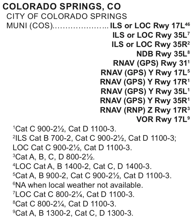
| COS approach | Category A | Category B |
|---|---|---|
| ILS or LOC 17L | ILS 600-2, LOC 1400-2; NA without local weather | Same |
| ILS or LOC 35L | ILS 600-2, LOC 800-2 | Same |
| ILS or LOC 35R | ILS 600-2, LOC 800-2 | ILS 700-2, LOC 800-2 |
| NDB 35L; RNAV (GPS) 31, Y 17R, Y 35L, Y 35R | 800-2 | 800-2 |
| RNAV (GPS) Y 17L | 900-2 | 900-2 |
| RNAV (RNP) Z 17R | 800-2½ | 800-2½ |
| VOR 17L | 1300-2 | 1300-2 |
A footnote that doesn't name your category leaves you on the standard minimums. A triangle A doesn't always mean higher minimums for your airplane. At Centennial (APA), every footnote covers only Categories C and D, so a piston single uses 600-2 and 800-2 there.
GPS and WAAS at the alternate
The limits depend on whether your GPS has WAAS. Basic GPS means a receiver approved under TSO-C129 or TSO-C196 (Technical Standard Order). WAAS means TSO-C145 or TSO-C146.
| Basic GPS | WAAS | |
|---|---|---|
| GPS approaches you may plan | At the destination or the alternate, not both | At both |
| Conditions | FDE, a RAIM prediction at the airport of the GPS approach, and the training to fly it | Approach-approved WAAS avionics |
| Plan the alternate on | LNAV or circling MDA; LNAV with vertical navigation (LNAV/VNAV) decision altitude (DA) only with approved barometric VNAV (baro-VNAV) | The LNAV or circling line, with nonprecision weather; LNAV/VNAV DA only with approved baro-VNAV |
| If the GPS approach is at the destination | The alternate needs an approach that doesn't use GPS, expected to be available at your ETA, that your airplane can fly | GPS approaches may be planned at both airports |
Sources: AIM 1-1-17, 1-1-18 and 1-2-3.
Without WAAS, when the GPS approach is at the destination, the approach you plan at the alternate can't use GPS even in place of a ground navaid (AIM 1-2-3). If that approach requires DME (distance measuring equipment) or an ADF (automatic direction finder), the airplane needs that equipment installed (IPH, chapter 1), and the same goes for a VOR used in an ILS missed approach. With WAAS, this substitution restriction doesn't apply (AIM 1-2-3).
Some RNAV (GPS) charts carry a W symbol, which means WAAS vertical guidance may fail there without a notice to air missions (NOTAM). Plan the LNAV or circling line at such an airport, as a destination or as an alternate (AIM 1-1-18).
The FAA is removing the NA from some RNAV (GPS) approaches so that WAAS users can plan them as alternates. Some keep it for other reasons, such as no weather reporting (AIM 1-1-18). The RNAV approach lesson covers the equipment and the RAIM check.
Alternate minimums are for planning
Alternate minimums decide whether you may list the airport on your flight plan. If you divert there, the approach's published landing minimums apply (IPH, chapter 4). With WAAS, if the receiver indicates LPV or LNAV/VNAV service when you arrive, you may use that vertical guidance (AIM 1-1-18).
Worked examples
The TAFs below are invented for this lesson. The charts and alternate minimums are real, from the cycle of 29 October to 26 November 2026.
Example 1: a TEMPO group in the window
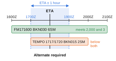
Situation: you're flying to Centennial (APA), which has several instrument approaches. Your ETA is 1800Z. The forecast:
TAF KAPA 171130Z 1712/1812 34008KT P6SM SCT050
  FM171600 20010KT 6SM -SHRA BKN030
  TEMPO 1717/1720 2SM SHRA BKN015
  FM180000 30012KT P6SM SCT060
- Your window runs from 1700Z to 1900Z.
- The FM171600 group covers the whole window: ceiling 3,000 feet, 6 miles. On its own it meets 2,000 and 3.
- The TEMPO group runs from 1700Z to 2000Z and overlaps the window. It forecasts a 1,500-foot ceiling and 2 miles, below both.
- You need an alternate. If your ETA were 2130Z, the window would start at 2030Z, after the TEMPO group ends, and the forecast in it (BKN030 6SM) would meet the rule.
Example 2: the category decides the approach
Situation: for the flight in example 1, you consider Colorado Springs (COS) as the alternate. Your ETA there would be 1900Z, and its forecast covering that time is:
FM171700 33006KT 3SM BR OVC006
- The ceiling is 600 feet and the visibility 3 miles. Assume local weather is available, so note 6 doesn't apply.
- Category A: the ILS 35R needs 600-2 (the standard minimums, because note 2 doesn't cover Category A). The forecast 600-foot ceiling meets the 600 feet, and 3 miles exceeds the 2. COS qualifies.
- Category B: the ILS 35R needs 700-2 (note 2), and 600 is below 700. The ILS 17L needs 600-2, because note 4 covers only its LOC line. COS qualifies on the ILS 17L.
Example 3: basic GPS, GPS approach at the destination
Situation: your destination is Meadow Lake (FLY), near Colorado Springs, whose only approaches are RNAV (GPS). The forecast requires an alternate. Your GPS is TSO-C129 with FDE, the RAIM prediction for FLY is good, and the airplane also has ILS and VOR receivers and DME. You plan COS as the alternate.
- You're planning a GPS approach at FLY, so the alternate needs an approach that doesn't use GPS (AIM 1-1-17).
- At COS that excludes the RNAV (GPS) approaches. The ILS, LOC, VOR and NDB approaches remain, if the airplane can fly them. Without an ADF, the NDB 35L is also excluded.
- Plan COS on an ILS approach, which has the lowest alternate minimums in the table for your category. A LOC approach, or the VOR 17L at 1300-2, also qualifies if the forecast meets its minimums.
Example 4: WAAS, an RNAV (GPS) approach at the alternate
Situation: the same flight to FLY in a Category A airplane with an approach-approved WAAS receiver. You'd like to plan the RNAV (GPS) Y RWY 17L at COS, which has an LPV line. The forecast for your ETA there is BKN009 4SM.
- The destination-or-alternate limit doesn't apply to WAAS, so you may plan GPS approaches at both airports (AIM 1-2-3).
- Plan the alternate on the LNAV line with nonprecision weather, not on the LPV line.
- The RNAV (GPS) Y 17L has nonstandard alternate minimums of 900-2 for Categories A and B (note 5). The forecast 900-foot ceiling meets the 900 feet, and 4 miles exceeds the 2. COS qualifies on this approach.
- If you divert to COS and the receiver indicates LPV service, you may fly the LPV line to its DA.
Example 5: Aspen, where 1-2-3 is met
Situation: a daytime flight to Aspen (ASE), elevation 7,838 feet, in a Category B airplane. From 1 hour before to 1 hour after your ETA, the forecast is BKN022 5SM.
- Aspen has an instrument approach, and 2,200 feet and 5 miles meet 2,000 and 3. 91.169 doesn't require an alternate.
- Aspen's two instrument approaches, the LOC/DME-E and the RNAV (GPS)-F, have only circling minimums. For Category B both MDAs are 10,220 feet, 2,382 feet above the airport, with 3 miles on the LOC/DME-E and 1¾ on the RNAV. Both procedures are NA at night.
- A 2,200-foot ceiling is below 2,382 feet above the airport on either approach, so you shouldn't count on completing either approach (AIM 5-1-10). Consider an alternate, and the fuel to reach it, even though the rule doesn't require one.
On the checkride
Alternates are tested in Area of Operation I of the Instrument Rating Airman Certification Standards (ACS, FAA-S-ACS-8C). In Task B you determine whether an alternate is required, and whether the one you selected meets the regulations (IR.I.B.S4). Task C lists primary and alternate airports in route planning (IR.I.C.K1d).
Try it: IFR alternates
All questions are for an airplane under Part 91. The TAF lines are invented for practice; the Colorado Springs minimums are from the chart cycle of 29 October 2026.
Your destination has an instrument approach. ETA 1500Z. Its TAF: FM141200 18010KT P6SM BKN040, then TEMPO 1415/1418 3SM -RA BKN018. Do you need an alternate?
Show the answer
Answer: B, Yes. The TEMPO group puts the ceiling below 2,000 feet inside the window. The window runs from 1400Z to 1600Z. The TEMPO group starts at 1500Z, inside it, and forecasts a 1,800-foot ceiling. Treat TEMPO and PROB30 groups like the prevailing forecast: the forecast no longer shows 2,000 feet for the whole window, so you need an alternate. The 3 miles alone would have met the rule.
- A. The prevailing group meets the rule, but the TEMPO group overlaps the window with a 1,800-foot ceiling.
- B. The TEMPO ceiling of 1,800 feet falls inside the 1400Z to 1600Z window.
- C. TEMPO and PROB30 groups are part of the forecast. Check them against the 1-2-3 rule like the prevailing conditions.
Reference: 14 CFR 91.169(b)(2)(i)
Your destination has no instrument approach procedure. The forecast for 1 hour either side of your ETA is SKC, visibility 10 miles. Do you need to file an alternate?
Show the answer
Answer: C, Yes. The exception needs an instrument approach at the destination. The exception in 91.169(b) needs two conditions: a published instrument approach at the first airport of intended landing, and the 1-2-3 forecast. With no approach, the first condition fails, so an alternate is required whatever the weather.
- A. The weather condition is met, but the exception also needs an instrument approach at the destination.
- B. The VFR descent from the MEA is how an airport with no approach can qualify as an alternate, not how a destination avoids needing one.
- C. Both conditions must hold, and the first one, an instrument approach, fails.
Reference: 14 CFR 91.169(b)(1)
Your destination has an RNAV (GPS) approach. From 1 hour before to 1 hour after your ETA, the forecast is 5SM BR SCT008 BKN025. Does 91.169 require an alternate?
Show the answer
Answer: A, No. The ceiling is 2,500 feet and the visibility 5 miles. A ceiling is the lowest layer reported as broken, overcast or obscuration. A scattered layer isn't one, so the ceiling is the broken layer at 2,500 feet. With 5 miles, the forecast meets 2,000 and 3, and no alternate is required.
- A. SCT008 isn't a ceiling. The ceiling is BKN025, and 5 miles meets the visibility requirement.
- B. Scattered isn't a ceiling. Only broken, overcast or an obscuration (VV) is.
- C. The rule tests only the ceiling and the visibility. Five miles in mist meets the 3-mile visibility requirement.
Reference: 14 CFR 1.1, Ceiling; 14 CFR 91.169(b)
You need an alternate. At what time must the forecast at the alternate meet its alternate minimums?
Show the answer
Answer: C, At your ETA at the alternate. 91.169(c) applies the alternate minimums at the estimated time of arrival at the alternate airport. The two-hour window belongs to the 1-2-3 test at the destination.
- A. That window is the 1-2-3 test at the destination, not the test at the alternate.
- B. The time is your arrival at the alternate.
- C. The regulation says the estimated time of arrival at the alternate airport.
Reference: 14 CFR 91.169(c)
Your alternate's only approach is an RNAV (GPS) with LPV, LNAV/VNAV and LNAV lines. The chart has no triangle A. Your airplane has WAAS and no baro-VNAV. What weather must the forecast show at your ETA there?
Show the answer
Answer: B, 800-2, the nonprecision standard, planning on the LNAV line. For alternate planning, RNAV (GPS) approaches are nonprecision, and with WAAS you plan the LNAV or circling line with the Part 91 nonprecision weather: 800-2 when the chart lists nothing else. If LPV is available when you arrive, you may use it.
- A. Only ILS, PAR and GLS count as precision for alternate planning. An LPV is planned as nonprecision.
- B. RNAV (GPS) is nonprecision for alternate planning, so with no triangle A the standard is 800-2.
- C. Landing minimums aren't the planning test. With WAAS, plan on the LNAV or circling line.
Reference: AIM 1-1-18; TPP, IFR Alternate Airport Minimums; IPH, chapter 4
Colorado Springs (COS) lists the ILS or LOC RWY 35R with note 2: "ILS Cat B 700-2, Cat C 900-2½, Cat D 1100-3; LOC Cat C 900-2½, Cat D 1100-3." What are the alternate minimums on the ILS for a Category A airplane?
Show the answer
Answer: A, 600-2, the standard precision minimums. The note sets nonstandard minimums only for the categories it names. Category A isn't named, so the standard precision minimums of 600-2 apply. A Category B airplane would need 700-2 on the same approach.
- A. The note doesn't name Category A, so the standard 600-2 applies.
- B. 700-2 is for Category B only. The note doesn't cover Category A.
- C. An approach that isn't authorized carries NA. Here Category A isn't named, so the standard minimums apply.
Reference: TPP, IFR Alternate Airport Minimums (SW-1, cycle 2611); 14 CFR 91.169(c)(1)(i)
Your GPS is TSO-C129 with FDE, not WAAS. Your destination's only approaches are RNAV (GPS), and you plan to fly one. Which airport can you plan as the alternate?
Show the answer
Answer: B, One with an ILS your airplane can fly. Without WAAS you may plan a GPS-based approach at the destination or the alternate, not both. Since you plan one at the destination, the alternate needs an approach that doesn't use GPS, expected to be available at your ETA, that the airplane is equipped to fly. Using GPS in place of the ground navaid there isn't allowed either.
- A. You're already planning a GPS approach at the destination, so the alternate can't rely on one.
- B. An ILS uses no GPS, so it meets the AIM's requirement if the airplane can fly it.
- C. Without WAAS, the alternate's approach can't use GPS as a substitute means of navigation.
Reference: AIM 1-1-17 and 1-2-3
You need an alternate. A nearby airport has no instrument approach. When can you list it as your alternate?
Show the answer
Answer: A, When the forecast for your ETA there allows a descent from the MEA, approach and landing under basic VFR. For an alternate with no instrument approach, 91.169(c)(2) requires weather that allows a descent from the MEA, approach and landing under basic VFR (the weather minimums of 91.155). It's a different case from a destination with no approach, which always needs an alternate, and from an approach marked NA, which can't be used whatever the forecast.
- A. 91.169(c)(2) sets this test for an alternate with no instrument approach.
- B. An airport with no approach can be an alternate. The weather has to allow a VFR descent from the MEA.
- C. 800-2 is the standard for a nonprecision approach. With no approach, the test is a VFR descent from the MEA.
Reference: 14 CFR 91.169(c)(2)
The only approach at a nearby airport carries a triangle A with NA. Its forecast for your ETA is clear with 10 miles, good enough for a VFR descent from the MEA. Can you list it as your required alternate?
Show the answer
Answer: C, No. An approach marked NA can't be used for an alternate. NA means alternate minimums are not authorized for that approach, because of an unmonitored facility, no weather reporting or a lack of navigation coverage. The FAA's Chief Counsel has said such an airport can't be listed as a required alternate even when the forecast would allow a VFR descent from the MEA.
- A. The VFR descent rule is for airports with no published approach. This one has an approach marked NA.
- B. NA means not authorized. No minimums make it usable.
- C. NA rules the approach out for alternate planning, whatever the forecast.
Reference: TPP, IFR Alternate Airport Minimums; FAA Chief Counsel, letter to Lloyd (2006)
You're flying to a mountain airport in daylight. Its forecast meets 2,000 and 3 for 1 hour either side of your ETA, but its only approaches are circling, with an MDA 2,382 feet above the airport. What applies?
Show the answer
Answer: A, 91.169 doesn't require an alternate, but the AIM cautions you to consider one. The 1-2-3 rule checks the forecast, not the destination's minimums, so no alternate is required. AIM 5-1-10 names airports like this (Aspen among them) where the forecast can relieve you of an alternate while the weather is below every approach, and cautions you to consider one anyway.
- A. The regulation is met, and the AIM's caution is guidance, not a rule.
- B. 91.169 has no test based on the MDA. The AIM caution is advice, not part of the regulation.
- C. Nothing prohibits the flight. The issue is planning an alternate and the fuel to reach it.
Reference: 14 CFR 91.169(b); AIM 5-1-10
Source: 14 CFR 91.169 and 1.1 (eCFR); AIM 1-1-17, 1-1-18, 1-2-3 and 5-1-10 (Change 3, July 2026); IPH (FAA-H-8083-16B), chapters 1 and 4; FAA TPP, cycle of 29 October 2026.
Next step
Sources and review
- 14 CFR 91.169, IFR flight plan: Information required (eCFR)
- 14 CFR 91.167, Fuel requirements for flight in IFR conditions (eCFR)
- 14 CFR 91.155, Basic VFR weather minimums (eCFR)
- 14 CFR 1.1, General definitions: ceiling (eCFR)
- 14 CFR 97.3, Definitions: aircraft approach category (eCFR)
- AIM 1-1-17, Global Positioning System (GPS), and 1-1-18, Wide Area Augmentation System (WAAS) (Change 3, effective 9 July 2026)
- AIM 1-2-3, Use of Suitable RNAV Systems on Conventional Procedures and Routes (Change 3, effective 9 July 2026)
- AIM 5-1-10, IFR Operations to High Altitude Destinations (Change 3, effective 9 July 2026)
- Pilot/Controller Glossary: Alternate Airport
- Instrument Procedures Handbook (FAA-H-8083-16B), chapter 1, IFR Alternate Requirements, and chapter 4, Weather Requirements and Part 91 Operators
- NWS Instruction 10-813, Terminal Aerodrome Forecasts (30 October 2024)
- FAA Chief Counsel, letter to Lloyd (28 December 2006): NA alternates
- FAA Chief Counsel, letter to Frisch, Air Wisconsin (27 June 2011): Exemption 3585
- Instrument Rating – Airplane ACS (FAA-S-ACS-8C), Area of Operation I, Tasks B and C
- FAA d-TPP, cycle 2611 (29 October to 26 November 2026): SW-1 IFR Alternate Airport Minimums; legend; Colorado Springs (COS) ILS or LOC RWY 35R, Amdt 2A, RNAV (GPS) Y RWY 17L, Amdt 3C, and RNAV (RNP) Z RWY 35R, Amdt 1A; Aspen (ASE) RNAV (GPS)-F, Orig-B, and LOC/DME-E, Amdt 1C
Spotted a mistake? Report a correction.
Last Updated:
This post may contain affiliate links or advertisements. This means I earn a small commission if you decide to make a purchase through the links at no extra cost to you.