12 min read
Heading, course, track, bearing and radial each answer a different question about direction. Where is the nose pointing? Where do you intend to fly? Where is the airplane going? Where is the station from you, and where are you from the station?
Each answer is a number in degrees. In still air, flying to a station on the course, the heading, the track, the course and the bearing to the station are the same number.
Put the airplane off the course in a crosswind, and all five can be different.
The five terms at a glance (Pilot/Controller Glossary; Pilot's Handbook of Aeronautical Knowledge, chapter 16; Instrument Flying Handbook, chapter 9)
- Heading: the direction the nose points. You control it, and ATC (Air Traffic Control) assigns it in a vector.
- Course: the direction you intend to fly over the ground. The chart or the clearance sets it.
- Track: the path the airplane makes over the ground. In a crosswind its direction differs from the heading.
- Bearing: the direction to or from a point (e.g., from the airplane to a station).
- Radial: a magnetic bearing from a VOR (Very High Frequency Omnidirectional Range) station. It depends on your position and not on your heading.
- Course on a radial: it equals the radial outbound and the radial ± 180° inbound.
- Magnetic bearing to a station = magnetic heading + relative bearing.
All five terms on one diagram
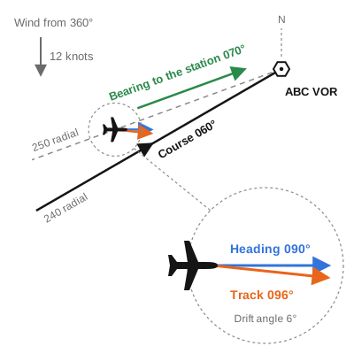
The airplane in the diagram is west-southwest of the ABC VOR. ATC has assigned a heading of 090° as a vector to intercept the 240 radial, which the airplane is cleared to fly inbound. Its true airspeed is 120 knots, the wind is from 360° at 12 knots, and all directions are magnetic.
| Term | Number | Where it comes from |
|---|---|---|
| Heading | 090° | An intercept heading 30° from the 060° course |
| Track | 096° | The wind from the left drifts the airplane 6° to the right |
| Course | 060° | The reciprocal of the 240 radial |
| Bearing to the station | 070° | The reciprocal of the radial the airplane is on |
| Radial | 250° | The airplane's position |
Heading and track
Heading is the direction in which the nose of the aircraft points during flight (Pilot's Handbook of Aeronautical Knowledge, PHAK, chapter 16). It is the number on the heading indicator, and the one you control directly.
Track is the actual flight path of the aircraft over the surface of the earth (Pilot/Controller Glossary, P/CG).
In still air the airplane goes where it points, and the track equals the heading. In a crosswind the airplane also moves with the air, so its track lies downwind of its heading.
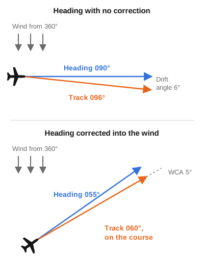
The angle between heading and track is the drift angle (PHAK, chapter 16). In the first diagram the wind is straight from the left of a 090° heading, the drift angle is about 6° (the arctangent of 12 ÷ 120), and the track is 096°.
To make the track follow a course, you turn into the wind by the wind correction angle (WCA), which is the angle between the desired track and the heading needed to stay on it (PHAK, glossary; see Example 2).
A holding entry is determined from the aircraft's heading on arrival at the fix. Many area navigation (RNAV) systems choose the entry from the ground track, which may result in an unexpected entry when the wind causes a large drift angle (AIM 5-3-8).
Course
Course is the intended direction of flight in the horizontal plane, measured in degrees from north (P/CG).
A course is set by the chart or the clearance (e.g., an airway or a leg of an approach procedure). You select it with the omnibearing selector (OBS) of a VOR indicator or the course pointer of a horizontal situation indicator (HSI), and the course deviation indicator (CDI) shows whether you are on it (Instrument Flying Handbook, IFH, chapter 9).
When the WCA matches the wind, track and course are identical (PHAK, chapter 16). The heading then differs from both by the WCA.
"Course" also names the signal pattern of a localizer, usually specified as the front course or the back course (P/CG). The instrument landing system (ILS) lesson covers both under the localizer.
Bearing and radial
Bearing is the horizontal direction to or from any point, usually measured clockwise from true north, magnetic north or another reference (P/CG).
A bearing is stated with its direction, to or from the point, and its reference (e.g., "the magnetic bearing to the station is 070°"). The bearing to a point and the bearing from it differ by 180°.
A radial is a magnetic bearing extending from a VOR, a tactical air navigation (TACAN) facility or a VORTAC (P/CG). A VORTAC is a VOR with TACAN equipment installed (IFH, chapter 9).
The VOR ground station is oriented to magnetic north, and the courses from the station are its radials (IFH, chapter 9).
The radial you are on depends only on your position. The VOR information an aircraft receives is not influenced by its attitude or heading (IFH, chapter 9), so turning the airplane leaves it on the same radial.
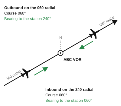
- Outbound, the course equals the radial (e.g., 060° on the 060 radial).
- Inbound, the course is the reciprocal of the radial (e.g., 060° on the 240 radial).
Set the OBS to the course you intend to fly. With the OBS on the reciprocal of the intended course, the CDI shows reverse sensing, and you would have to turn away from the needle to correct (IFH, chapter 9).
A nondirectional beacon (NDB) has bearings and no radials, because a radial comes only from a VOR, a TACAN or a VORTAC (P/CG). ATC names a VOR radial as "ABC two four zero radial" and describes an NDB by the "course to" or the "bearing from" the beacon (Federal Aviation Administration, FAA, Order JO 7110.65, 2-5-2).
Relative bearing
Relative bearing (RB) is the angular difference between the aircraft's heading and the direction to the station, measured clockwise from the nose (IFH, glossary).
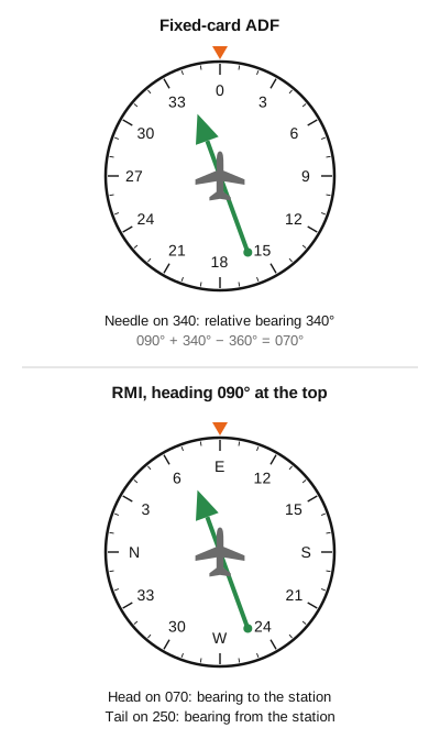
A fixed-card automatic direction finder (ADF) shows relative bearing, with 0° always at the top of the card. To find the magnetic bearing (MB) to the station, add the magnetic heading (MH) to the relative bearing (IFH, chapter 9):
MB to the station = MH + RB
Subtract 360° when the sum is more than 360°. With an NDB in place of the ABC VOR in the first diagram, the station is 20° left of the nose, a relative bearing of 340°. Then 090° + 340° = 430°, and 430° − 360° = 070°.
A radio magnetic indicator (RMI) does the addition by rotating its card automatically to the aircraft's heading. On a movable-card ADF you rotate the card to the heading yourself. With the heading at the top of the card, the head of the needle shows the magnetic bearing to the station and the tail shows the magnetic bearing from it (IFH, chapter 9).
Which numbers are magnetic and which are true
- Radials are magnetic (P/CG).
- Courses on instrument charts are magnetic. Each leg is computed along a true track and published after a magnetic variation correction (Aeronautical Information Manual, AIM, 1-1-17).
- Winds on voice broadcasts (the automatic terminal information service, ATIS, and automated weather stations) are magnetic (AIM 7-1-10).
- Winds in forecasts (winds aloft forecasts and terminal aerodrome forecasts) are true (PHAK, chapter 13).
A global positioning system (GPS) receiver may apply a different magnetic variation from the one used for the chart, so the course it shows can differ from the charted magnetic course (AIM 1-1-17).
Where each term appears
| You hear or see | The term | What you do |
|---|---|---|
| "Fly heading 090" | Heading. A vector is a heading issued for navigational guidance by radar (P/CG) | Turn to 090° and maintain it. On vectors to the final approach course, pilots must not deviate from the headings approach control issues (AIM 5-4-3) |
| "Vector to intercept the ABC two four zero radial" | Heading, then radial (JO 7110.65, 5-6-2) | Fly the heading until the CDI centers, then turn onto the course along the radial (IFH, chapter 9) |
| "Cleared direct ABC" (JO 7110.65, 4-2-5) | Course | Fly a straight line to the fix (P/CG, Direct) |
| "Resume own navigation" | Course | Navigate by your own means again. ATC issues it after a vector, or when radar contact is lost during one (P/CG) |
| "Hold west of ABC on the two seven zero radial" (JO 7110.65, 4-6-4) | Radial | Hold on an inbound course of 090° (holding lesson) |
| The Centennial ILS or LOC (localizer) RWY 35R approach chart: final approach course 350° | Course | Fly the localizer course of 350° |
| The same chart's missed approach: heading 160°, then the FQF VORTAC 197 radial | Heading, then radial | Fly the heading until you intercept the radial |
Garmin GPS avionics show the course, the track, the bearing and the distance off the course in four fields (Garmin 400W Series Pilot's Guide).
- DTK (Desired Track): the course between the active waypoints.
- TRK (Track): the direction the airplane is moving over the ground.
- BRG (Bearing): the direction from your present position to the waypoint.
- XTK (Crosstrack Error): your distance left or right of the course.
When the airplane is on the course and its track follows it, DTK, TRK and BRG are about equal and XTK is zero. They can differ slightly because the direction of a great-circle leg changes from point to point along it (P/CG, Desired Track).
FAA and ICAO terms. The P/CG carries a separate International Civil Aviation Organization (ICAO) definition of track: the projection on the earth's surface of the path of an aircraft, with its direction usually expressed in degrees from true, magnetic or grid north. GPS avionics label the course "desired track", which the P/CG defines as the planned or intended track between two waypoints.
Worked examples
Examples 1 to 3 follow the airplane in the first diagram: 120 knots true airspeed, wind from 360° at 12 knots.
Example 1: setting the course for the 240 radial inbound
Situation: you're on the 250 radial, heading 090°, on a vector to intercept the ABC 240 radial and fly it inbound.
- Inbound, the course is the reciprocal of the radial. 240° − 180° = 060°, and 060 goes in the OBS.
- The TO/FROM indicator shows TO, because the 060° course, intercepted and flown, takes you to the station (IFH, chapter 9).
- You're 250° − 240° = 10° off the course, which is to your right. The needle sits on the fourth dot right of center: the edge of the center circle is 2° and each dot adds 2° (IFH, chapter 9).
- When the needle centers you are on the 240 radial. Turn left onto the 060° course, with the heading from Example 2.
Example 2: on the course, with a wind correction
Situation: you're on the 060° course to the station.
- The wind is from 60° left of the course. The crosswind is 12 × sin 60° = 10.4 knots.
- WCA = arcsin (10.4 ÷ 120) = 5°, to the left.
- Heading = 060° − 5° = 055°.
| Term | Number |
|---|---|
| Heading | 055° |
| Track | 060° |
| Course | 060° |
| Bearing to the station | 060° |
| Radial | 240° |
Example 3: crossing the station
Situation: you pass over ABC and continue on the same course.
- You're now on the 060 radial. Outbound, the radial equals the course.
- The bearing to the station is 060° + 180° = 240°. The station is behind you, at a relative bearing of 240° − 055° = 185°.
- The heading stays 055° and the track 060°. Leave the OBS on 060.
Example 4: DTK equals TRK, one mile off the course
Situation: on a GPS leg with a DTK of 060° to a waypoint 15 nautical miles (NM) ahead, the GPS shows TRK 060° and XTK 1.0 NM, with the course to your right.
- TRK equals DTK, so you're flying parallel to the course and the 1.0 NM will not close.
- BRG = 060° + arctan (1 ÷ 15) = 060° + 4° = 064°. A bearing greater than the DTK puts the waypoint to the right of your track.
- A track greater than 060° closes with the course, and XTK counts down to zero as it does.
On the checkride
Two tasks in the Instrument Rating Airman Certification Standards (ACS) test these terms.
- Compliance with ATC clearances (III.A): intercept all courses, radials and bearings appropriate to the procedure, route or clearance.
- Intercepting and tracking (V.A): maintain selected headings within ±5°, and maintain a course with no more than ¾-scale deflection of the CDI.
Next step
Sources and review
- Pilot/Controller Glossary (basic with Changes 1 to 3, effective 9 July 2026): Bearing, Course, Desired Track, Direct, Final Approach Course, Radial, Resume Own Navigation, Track, Vector
- Pilot's Handbook of Aeronautical Knowledge (FAA-H-8083-25C), chapter 13, Aviation Weather Services; chapter 16, Navigation; and glossary
- Instrument Flying Handbook (FAA-H-8083-15B), chapter 9, Navigation Systems, and glossary
- AIM 1-1-17, Global Positioning System (GPS) (Change 3, effective 9 July 2026)
- AIM 5-3-8, Holding (Change 3, effective 9 July 2026)
- AIM 5-4-3, Approach Control (Change 3, effective 9 July 2026)
- AIM 7-1-10, Weather Observing Programs (Change 3, effective 9 July 2026)
- FAA Order JO 7110.65BB, Air Traffic Control, 2-5-2, NAVAID Terms; 4-2-5, Route or Altitude Amendments; 4-6-4, Holding Instructions; and 5-6-2, Methods (Change 3, effective 9 July 2026)
- Instrument Rating – Airplane ACS (FAA-S-ACS-8C), Area of Operation III, Task A, and Area of Operation V, Task A
- Garmin 400W Series Pilot's Guide and Reference (190-00356-00, Rev. K, January 2016), Navigation Terms
- FAA d-TPP, cycle 2611 (29 October to 26 November 2026): Centennial (APA) ILS or LOC RWY 35R, Amdt 11B
Spotted a mistake? Report a correction.
Last Updated:
This post may contain affiliate links or advertisements. This means I earn a small commission if you decide to make a purchase through the links at no extra cost to you.