
4 min read
GPS and RNAV approach terminology can be very confusing since modern RNAV procedures usually accommodate more than one type of navigational equipment (such as basic GPS, WAAS, LAAS or multi-sensor FMS) on the same chart. With older types of approach procedures, the specific equipment required is stated in the chart title. For example, you could only fly a “VOR RWY XX” approach with VOR equipment, or an ILS approach with ILS equipment.
The FAA classifies instrument approach procedures into three categories:
- Non-precision approaches: Provide lateral guidance (left or right off-course) but no vertical guidance (above or below the glide path). Terrain clearance is maintained with step-down fixes and a Minimum Descent Altitude (MDA). The pilot must stay at or above the MDA until starting the visual descent to landing. If the conditions for a visual descent are not available, the pilot must shoot the missed approach procedure upon reaching the missed approach point, which is usually over the airport.
- Precision approaches: In addition to the lateral guidance provided by non-precision procedures, precision approaches provide a glideslope to follow down to a Decision Altitude (DA). Upon reaching the DA on the glideslope, the pilot must decide whether to continue to land or must immediately start the missed approach procedure.
- Approach with Vertical guidance (APV): describes precision-like approaches that do not fully comply with ICAO’s annex 10 precision approach requirements. APVs, like precision approaches, are flown to a DA, not an MDA.
Ground-based approach procedures, such as ILS or VOR approaches, require expensive facilities to be installed at or around the airport and are limited to point-to-point navigation. On the other hand, area Navigation (RNAV) equipment can guide you over any virtual waypoint, which does not necessarily represent an actual ground facility. Therefore, RNAV approaches make more airports accessible under instrument conditions.
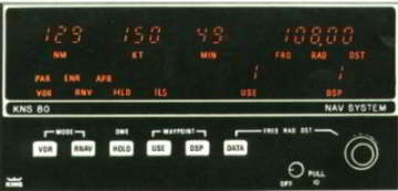
The Bendix KNS-80 is capable of older VOR/DME RNAV approaches. RNAV-based approaches have been around for a while for Flight Management Systems and for the old style VOR/DME RNAV units (which compute your position by bearing and distance to a nearby VORTAC), but only later were available for GPS. Note that you cannot use a GPS to shoot approach procedures titled “VOR/DME RNAV RWY XX,” unless it also says “or GPS” in the title. Only VOR/DME RNAV systems can be used for these approaches.
The FAA developed early GPS approaches as “overlays” of existing non-precision approaches, with “or GPS” in their title. For example, the “VOR or GPS RWY XX” procedure can be flown with either a VOR or a GPS installed in your aircraft.
Other procedures were designed as completely new “standalone” GPS approaches, titled “GPS RWY XX,” which can only be flown with a GPS unit.
Nowadays, in an effort to reduce the number of approach charts, the FAA consolidates the different types of RNAV and GPS approaches into charts titled: “RNAV(GPS) RWY XX.” These approaches can be flown with either a GPS or an approved FMS. Note that many RNAV(GPS) approaches call for a GPS as the main navigation sensor, by notation “GPS required” or may have other limitations on non-GPS equipment such as “DME/DME RNP 0.3 NA”.
Minimas found on RNAV(GPS) approach charts:
- LNAV: A non-precision approach providing only lateral guidance, left and right of course, flown down to an MDA . You can fly to LNAV minimums with basic IFR GPS receivers, with or without augmentation. Some GPS units have a feature called “LNAV+V” which provides you with a virtual glideslope to smooth out the descent. However, you are still flying to the LNAV minimums, and must stay above all step down fixes and the MDA.
- LNAV/VNAV: A precision-like Approach with Vertical guidance (APV) flown to a DA on a glideslope. You can fly to LNAV/VNAV minimums using a WAAS (Wide Area Augmentation System) GPS receiver or a FMS with baro-VNAV.
- LPV (Localizer-Performance with Vertical guidance): An APV (“precision-like”) approach which, unlike LNAV/VNAV, you cannot fly without a WAAS GPS receiver. LPVs are flown to minimums as low as those equivalent to category I ILS approach (200 ft Decision Height and ½ SM visibility). The final approach leg of an LPV requires a 40 meter (131 ft) accuracy, which is much more precise than the 0.3 NM requiremet of LNAV or LNAV/VNAV final approach legs.
- LP (Localizer Performance approaches): These are new minimas that refer to an approach with a WAAS-equipped GPS, but with no glideslope due to terrain or other limitations. LP approaches are flown to an MDA and are non-precision approaches. An important thing to make sure before you use LP minimas is that your WAAS-equipped receiver is approved for it. Old WAAS receivers, even if approved for LPV, may not be approved for LP minimas. The Airplane Flight Manual (AFM) or supplements should list the approach types approved with its equipment.
- GLS (GNSS Landing System): GNSS, or Global Navigation Satellite System, is a broad term describing satellite navigation systems such as GPS (USA), GLONASS(Russia) or Galileo (EU). In the future, systems other than GPS may be allowed for this purpose and therefore the term GNSS, not GPS, is used. For GLS approaches you’ll need a GNSS with a Ground Based Augmentation System (GBAS) such as LAAS (Local Area Augmentation System) in the U.S. GLS will provide a higher level of accuracy than LPV approaches and can be flown to lower minimums, comparable with ILS categories II and III.
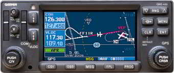
Garmin GNS-430W a WAAS GPS capable of LPV and LNAV/VNAV approaches. The term “RNP,” or Required Navigation Performance, is a statement of required navigation accuracy in a given airspace. For example, RNP 1.0 requires an accuracy of 1 NM from the course center line 95% of the time. An RNP aircraft is an RNAV aircraft with the added capability to monitor the achieved navigational performance at all times.
Charts titled “RNAV(RNP) RWY XX” notate minimas in RNP values (such as: 0.13, 0.19 or 0.1 RNP), unlike the minimas found on RNAV(GPS) approaches which have names such as “LNAV,” “LNAV/VNAV,” and “LPV”. RNP approaches provide a few benefits over WAAS: They let you navigate through curved paths, may start at higher altitudes (reducing ATC radar vectoring and communication) and provide the highest level of accuracy throughout the approach, not just at the final approach segment.
Currently, all RNP approaches in the U.S. require special aircrew training and aircraft equipment (called SAAAR – Special Aircrew And Aircraft Authorization Required by the FAA, or AR – Authorization Required by ICAO). In particular you’ll need a Flight Management System with multi-sensor inputs (not only GPS, but additional navigation sensors, such as Inertial Reference Units, baro-vnav or DME/DME RNAV ). As a result, you can’t currently fly these approaches with the common general aviation aircraft.
As you see, RNAV and GPS approach terminology can get tricky and, as with any other type of instrument procedure, it’s very important to make sure your equipment is capable and legal for the approach you’re about the shoot. The approaches your aircraft is legal and capable of flying with your RNAV or GPS equipment should be specified in the AFM, company’s OPSPECs (Operation Specifiaction), or in other FAA aircraft documents.
Recommended Reading


This post may contain affiliate links or advertisements. This means I earn a small commision if you decide to make a purchase through the links at no extra cost to you.